
map every inch
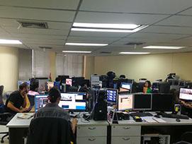
data processing unit
MMS Applications
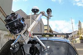
Iwane Mobile Mapping System is perfect for 3D street-view city mapping and provides essential information for many applications.
SERVICE
Iwane provides turnkey Mobile Mapping Services in other countries which includes straight from MMS mobilization, data acquisition, post processing (locally or outside), software applications, on the top development, customization and system integration work. We are one of the few companies who offer this unique data collection services to clients in the private and public sector. We understand client requirements in detail and suggest the best ways to meet the client expectations. This is because we have a huge experience in providing services, accomplished many projects in past and performed nationa-wide and city wide mapping in Japan , Hong Kong , Thailand , Turkey , KSA ,etc... With our experience working with government & private clients, we can suggest the best way to output required results.
Iwane consulting owns and operates its mobile mapping system depending upon the client requirements. Our service offers various options for the hosting and application processing of the mobile mapping data to suit the needs of any scale of customer organization. In some cases the customer may be best qualified and resourced to extract data (e.g. carriageway inspection), whereas in other cases the processing is best out-sourced to either Iwane or other third party providers. Whatever the model, Iwane offers the applications to ensure ultimate flexibility.
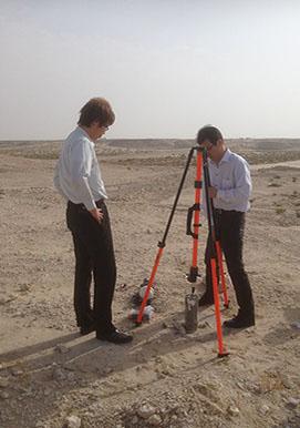
If the mapping project demands or in case when MMS data cannot be taken outside the country for post processing, or in some turnkey project, Iwane is well capable of setting up a data processing unit in other countries and deliver results.
We are providing our services to Highway Department, Public Works/ Municipalities, Cadastral & Mapping Bureau/ Geo spatial data hubs, Lands Information Center, Urban Planning Departments, Defense Departments, Housing Authorities, Disaster, Prevention and Mitigation, Tourism board, Housing & Architecture Departments.
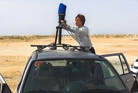
Iwane is also specialized in indoor mapping and do provide services wherein Iwane shooting specialist capture indoor data using Iwane’s backpack system, post process and deliver geo spatial video's and 3D Computer Graphics models depending upon project requirement.
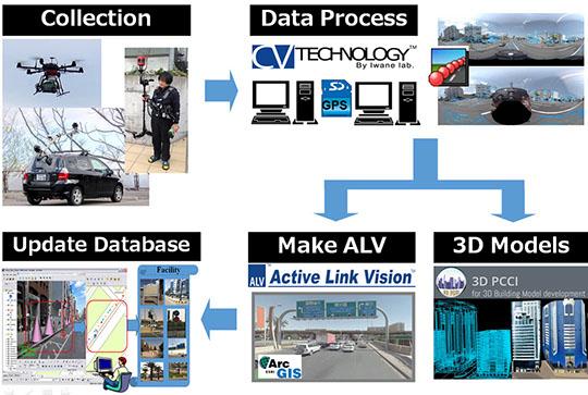
Work flow and Applications
Our professional service team will work directly with you to find the best solution to fit your needs. You can reach sales team by e-mail at This email address is being protected from spambots. You need JavaScript enabled to view it..
The Methodology for the acquisition of Geo spatial video /360 degree Geo images by using the technology of Iwane Mobile Mapping System can be downloaded <Methodology >.
Using Gopro fusion 360 or Garmin Virb 360 ? If yes, then we can provide professional data processing service wherein we will process your data ( mp4 + GPS ) using our technology and it can use with our software’s for GIS database development , measurement and Geo-tagging. Send your video (via FTP ) and we will convince you about the quality of the data we produce and the numerous advantages of the services we offer. Provide small section of video sequence and we will analyze for free. If you are interested in further details, please do not hesitate to contact us at This email address is being protected from spambots. You need JavaScript enabled to view it.
MMS Applications
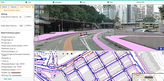
Highway mapping can be performed rapidly and efficiently using Iwane MMS. All the road inventory & road furniture’s like manhole, gully trap, railing, fence, banner, trees, etc.. can be mapped, processed and extracted. Iwane provides a significant improvement in the way departments visualize, measure and map – and a whole new way to populate GIS with MMS data.
Roadway Mapping, Inspection & Management
Highway mapping can be performed rapidly and efficiently using Iwane MMS. All the road inventory & road furniture’s like manhole, gully trap, railing, fence, banner, trees, etc.. can be mapped, processed and extracted. Iwane provides a significant improvement in the way departments visualize, measure and map – and a whole new way to populate GIS with MMS data.
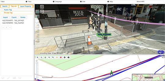
Road Asset Management (Feature Inventory)
Using MMS application software, road inventory can be populated at a much higher accuracy. The same road can be captured twice (up and down) if the road width is wide enough. Capturing data at a high rate (16 FPS) help to reduce less supplementary survey because one single object/feature on the road side can be visualized by many frames.
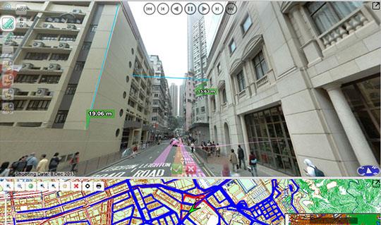
Analysis (Measure and Survey)
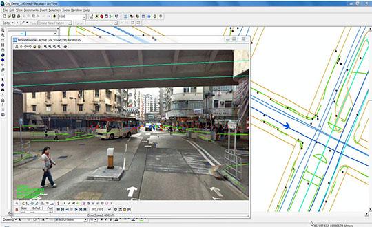
Measurement and survey can be performed easily with respect to location. Measurement can be performed by only single click and allow measurement to be performed within and across the frame. This gives a tremendous add on value to images and as a result MMS data is very useful for municipalities, public works and many other departments.
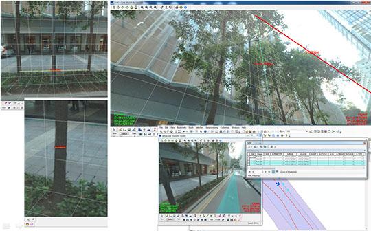
Tree Mapping & Management
Tree can be mapped & managed using Iwane MMS data. Tree can be digitize as a point feature, measure the height and diameter (certain height from the ground) and add on the attributes based on the characteristics. In addition, the picture of tree can be taken and associate any document file like text, pdf, ms-Word,etc..
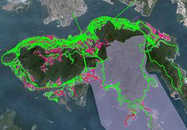
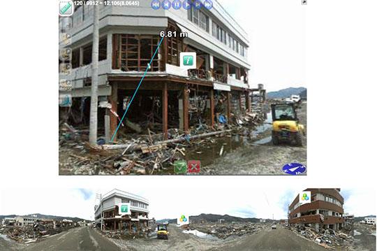
Disaster Mapping (Post-Disaster Damage Information Collection)
Iwane MMS is fast, reliable and accurate in terms of mapping disaster affected areas. Due to flexibility of MMS which we offer, we can map the accessible and in-accessible areas with the help of MMS mounted on the car, cart and backpack MMS. Using MMS data, inspectors can quickly access the extent of disaster and investigate scenes and damages much more fast, effective and with precise accuracy.
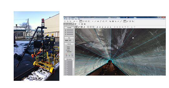
Railway & Tunnel Survey
Iwane designs innovative imagery and geo-positioning technologies to enable simple, accurate and cost effective large scale rail surveying. Due to the innovative system of Iwane MMS , it delivers proven accuracies in the most challenging environments. The data can be used for situational awareness, clearance measurement, measurement of object , track spacing , asset management, etc..
Utility Corridor Mapping
Electric Utilities like lamp post, electric tension lines, stations can be mapped effectively with Iwane MMS system. The height and the dimensions can be measured and also analyzed the high tension wires in case of sagging.
Defense and Security
Iwane MMS provides a variety of unique products and services oriented towards the collection of Terrestrial Intelligence, Surveillance and Reconnaissance information to various Government agencies like security and defense. Military, law enforcement and security forces use these immersive technologies for advanced monitoring, planning, protection and response. Our geo spatial videos are also invaluable for situational training and pre-mission briefings. Police Security and public safety teams can utilize ALV for ArcGIS, Web ALV and Mobile ALP solution that delivers all surrounding surveillance.
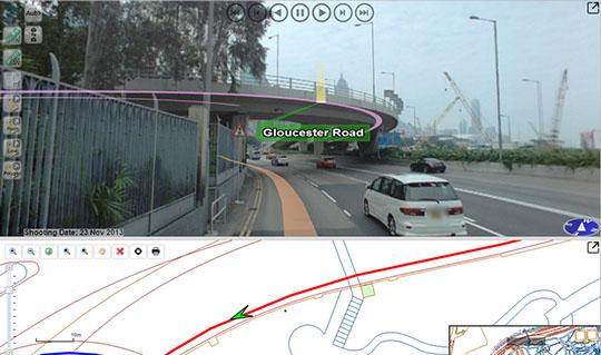
3D Street-view city mapping
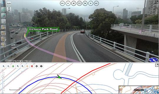
360 degree 3D street View can be captured by using Iwane MMS at higher resolution and the data can be disseminated on to the web with the help of MMS Server application. User can perform nearly similar functionalities of desktop i.e. measurement, geo tagging, link with any web mapping service, populate geo database or extract and retrieve information.
MMS Data Management
Mobile Data Management is very important when it comes to data related with Mobile Mapping System. Most important is when the user have to collect data of big project and /or nationwide project . We provide MMS application using which one can register all MMS processed data in one go or disseminate all the captured routes with the help of MMS Server (Iwane MMS Server).
Plant and Pipeline Mapping
Using the Vehicle and /or backpack iwane mobile mapping system, premises (indoor & outdoor) of the plants & factories can be mapped easily and efficiently. The geo digital MMS content captured from MMS can be used for documentation, survey of industrial facilities, perform accurate measurements for the control of construction, create plan and maps, performing architectural measurements of buildings, simulate emergency, security , planning, capturing the linear objects of pipeline transportation, and performing other activities to visualize and model. Indoor areas can tag/ geo-tag any object and fill in information and dimension of the object. The video's can be geo referenced with the help of few manual surveyed control points. These simple back pack systems are ideal for users who are new to the mobile mapping business, since they are easy to operate, calibrate, and transport.