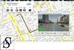


https://www.iwane.com/eng/products/alvforwebbrowser#sigProId452db1fe0d
ALV for Web Browser is a web based server using which Iwane Mobile Mapping System data can be disseminated on to the web linked with location on the map e.g. with Google Maps, Bing Maps, Open Street Maps, etc. In this, one can use any web mapping service to link 360 degree geo referenced images.
Web programmers can use advanced API's and can customize ALV for Web Browser as per their choice and requirements. JavaScript interface allows full viewer control in web page. Fully configurable UI for placement of UI navigation control , widgets and other UI elements. All user generated events triggers callbacks that can be trapped in JavaScript.
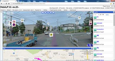
The 360-degree geo imagery can be browsed using web browser like IE7, 8×, Chrome, etc. It's a flash based application and web browser's need to be flash enable in order to browse 360 degree geo imagery online. High resolution viewing of imagery can be possible with ALV for Web browser. It can disseminate cubic imagery with a resolution of up to 5,400 X 2,700 Pixel or more ( 30 M Pixel /frame ) using the cube tile format . In short, It is designed in a way to offer's instant 360 degree loading even over low bandwidth. Unique transition effects allows for seamless switching/navigation in and between images. Support for transitions between Street imagery and bird’s eye view is also provided as a built-in feature.
Using this different resolution of image can be disseminated and the navigation between the images is much faster. Web ALV has a standard API's using which user can link Web ALV with other web mapping service. Using Web ALV, user can build its own street views and share data within or outside organizations.
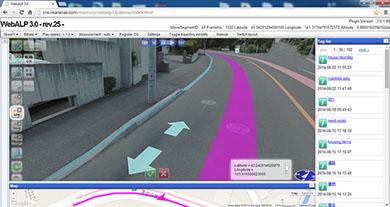
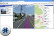
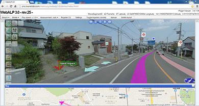
Looking at the national securities issues or data privacy, we provide end to end platform to government organization to build its own 360 degree 3D content and disseminate using their own portal. The 3D coordinates of the features inside the image are calculated on the fly and allow 3D measurement, geo tagging and population of road inventory.
Software & Hardware Requirments
System Requirements of ALV for Web Browser
■ Operation System (OS) - Windows Server 2008 R2; x64 / Windows Server 2012; x64 / Windows Server 2012 R2; x64
■ Processer (CPU) - Intel Xeon Processor - E5-1410 2.8 GHZ or better
■ Memory (RAM) - 8GB or higher
■ Storage Space (Hard disk) < 1GB for WebALP3.0 Service
■ USB Port- 1 (for a dongle license only)
Pre-requisite Software's for ALV for Web Browser
■ Microsoft Internet Information Services (IIS) 7.5 or 8.0
■ ASP.NET (for IIS7.5) or APS.NET4.5 (for IIS8.0)
■ Microsoft .NET 4.5 or higher
■ Visual c++ redistributable for visual studio 2012
■ PostgreSQL 9.3.X
■ PostGIS 2.1.X
■ Sentinel HASP/LDK 6.63 Run-time (for a dongle license only)
■ Adobe Media Server 5
*Not included in a WebALP3.0 Installer bundle.
Key Features
■ Advanced API available to link with other web mapping service;
■ Flexible customization of User Interface;
■ Mash up with other web mapping service;
■ Dedicated to Government clients;
■ Most Advanced 360 (panorama) application on the web with unique features & functions;
■ Proven technology and world wide acceptance;
■ Launch Street Views 3 years before Google launch street views;
Key Functionalities
■ 360 degree Complete Spherical Video on web;
■ Support for higher resolution / different kind of image resolutions;
■ Click on the map and jump to Image;
■ Geo tagging;
□ Add user based information
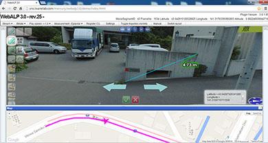
■ 3D Measurement (within and across the frame);
□ Measurement in 3D
□ Measurement using Cube Grid
□ Measurement using Horizontal Grid
■ Population of Geo database;
□ Point, Line and Polygon;
■ Can browse the information of any feature/object;
■ Identity & Search function;
■ Can view the bird eye view (if no linkage with map);
■ Flexibility to display road name and change the color of the road;
■ Change the layout from landscape to portrait;
■ Support English, Thai and Japanese language;
Service
■ Turnkey services – Straight from Data Acquisition to Data Hoisting;
■ System Integration;
■ Provision for onsite training, installation, upgrade and maintenance;